
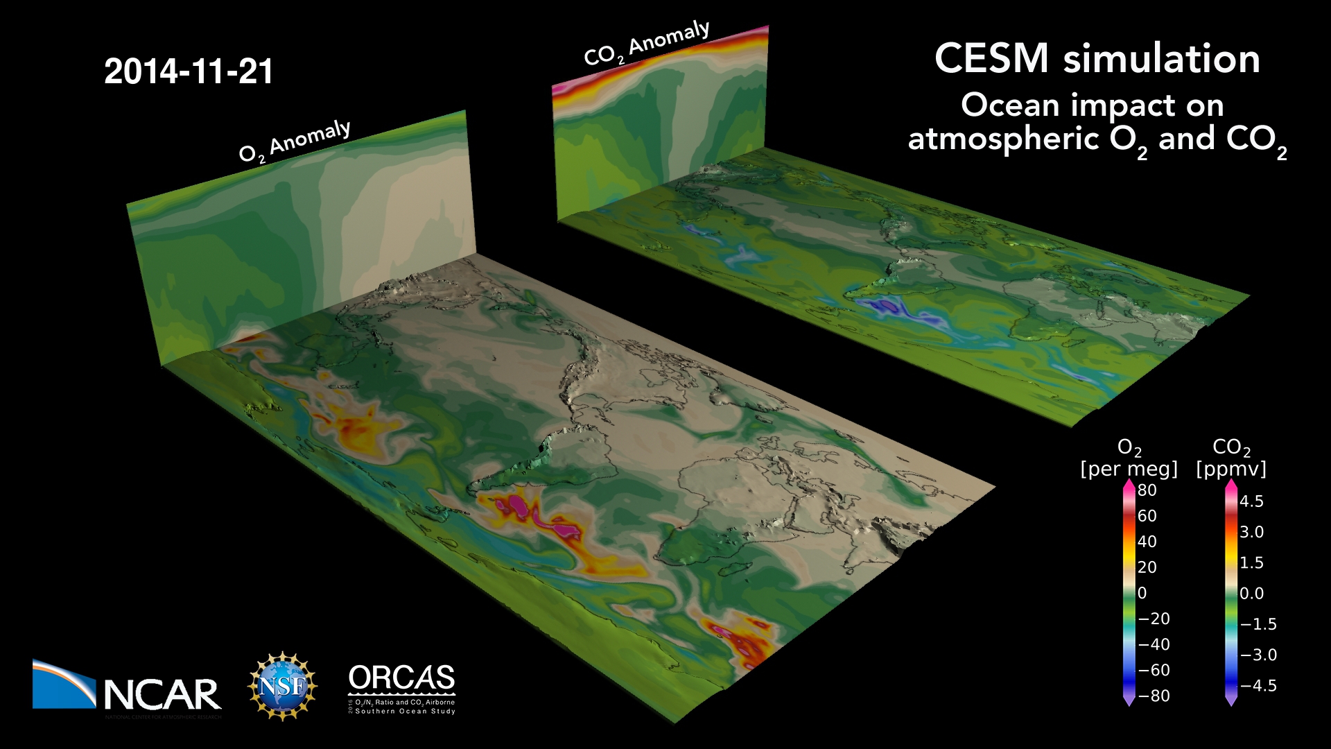
The ocean breathes: a map of oxygen and carbon dioxide variations in the atmosphere due to air-sea gas exchange, stirred by winds. The ocean absorbs CO2 and releases O2 in the summer hemisphere, primarily due to photosynthesis (and warming, for O2) at the surface; the reverse happens during winter when the surface cools and deep…
Read moreAuthor: VAST Staff
Surface Ozone Concentrations on the Colorado Front Range
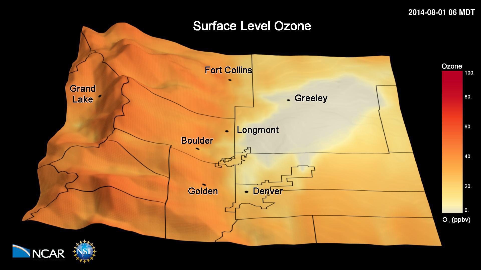
This animation shows simulated hourly surface ozone concentrations during the 2014 FRAPPÉ campaign. The simulations have been performed with the Weather Research and Forecasting (WRF) Community Multiscale Air Quality (CMAQ) model. The simulations have been conducted with a 4 km x 4 km grid horizontal resolution and show the frequent occurrence of high ozone pollution…
Read moreTotal Accumulation of Global Precipitation
Project Metis: Seasonal Forecasts with Enhanced Ocean and Atmosphere Resolution This visualization shows total accumulation of global precipitation (blue/purple) and the 6-hourly precipitation (yellow/red) between May 1 and Nov 1, 2015. What to look for: Of particular interest are the cyclones that scrawl lines across the map, leaving a visible trail in the total precipitation field. Movies Movie…
Read moreRadiative MHD Simulation of a Solar Active Region
Radiative MHD Simulation of a Solar Active Region from Flux Emergence to Coronal Mass Ejections. Movies Movie File (.mp4, 621MB, 1920×1080) Images Computational Modeling Matthias Rempel (NCAR/HAO) Feng Chen (NCAR/HAO, University of Colorado/LASP) Visualization and Post-production John Clyne and Matt Rehme (NCAR/CISL) Acknowledgments This work was supported by the National Science Foundation and NCAR’s Advanced…
Read moreVariable Resolution Regional Climate Simulations with CESM
This visualization shows the output from a Variable Resolution Regional Climate Simulations with CESM (Community Earth System Model). Movies Movie File (.mp4, 319MB, 1920×1080) Images Computational Modeling Colin Zarzycki, Andrew Gettelman, Peter Lauritzen and Patrick Callaghan (NCAR/CGD) Visualization and Post-production John Clyne and Matt Rehme (NCAR/CISL) Model Variable Resolution Regional Climate Simulations with CESM (Community…
Read moreSurface Temperatures from Climate Change vs. Geoengineering
This visualization describes temperature changes relative to years 2015-2024 from unabated climate change (RCP8.5) and stratospheric sulfate aerosol geoengineering (using feedback) simulated by a state-of-the-art coupled earth system model. Geoengineering, often using stratospheric sulfate aerosols, is discussed as a potential means of deliberately offsetting some of the effects of climate change, such as rising temperatures.…
Read moreDeep Water Impact Ensemble Data Set
The Deep Water Impact Ensemble Data Set was generated from large simulations of asteroids crashing into the ocean. These simulations were run using various sizes of asteroids and angles of entry in order to study the aftermath of the impacts. The data set was the subject matter for the 2018 IEEE VIS SciVis Contest, held…
Read moreModelling The Indonesian Throughflow
Rising ocean temperatures have given rise to coral bleaching events at higher rates than have been seen in observed history. Researchers at the National Center for Atmospheric Research are studying how effectively coral reef ecosystems can repopulate each other after bleaching events through a metric called Potential Connectivity. In this visualization, we observe a state…
Read moreYarnell Hill Fire
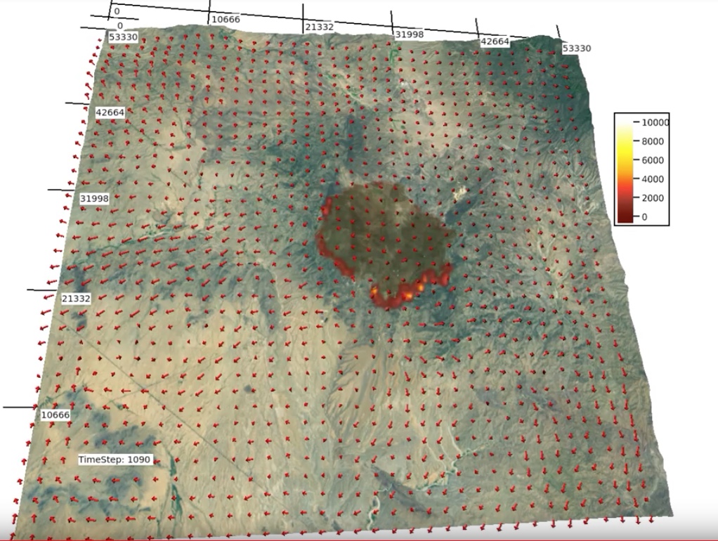
Ignition: 6/28/13 near Yarnell, Arizona Movies Images Science Credits Principle Investigator: Janice Cohen (NCAR) Collaborator: Wilfrid Schroeder (Univ. of Maryland) Visualization Software VAPOR
Read moreKing Fire 2014
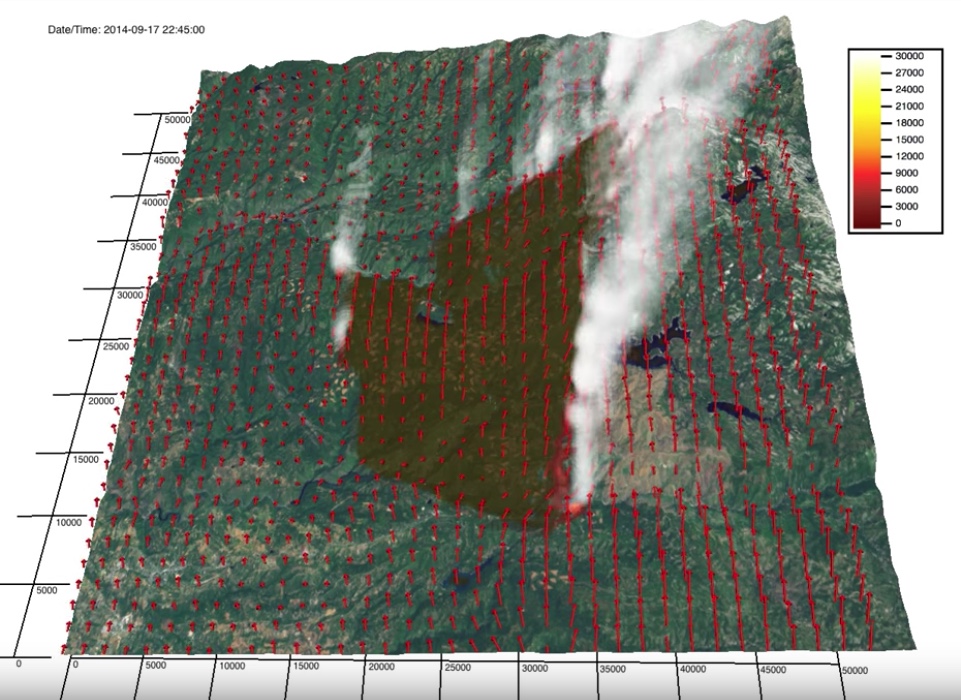
The King Fire was ignited on 9/13/14 in the Eldorado National Forest northeast of Pollock Pines, CA, where pine plantations lie between steep canyons. Eventhough fuel conditions were dry, environmental winds recorded at nearby weather stations were weak, thus rapid fire growth was not expected. On the 17th, the north-spreading fire reached the Rubicon canyon…
Read more